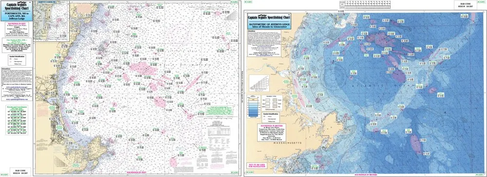
Welcome to the world of fishing with the Captain Segull Bathymetric Chart, specifically designed for the coastal waters around Cape Ann and Jeffrey’s Ledge, Massachusetts. This fishing chart is not just a piece of paper; it is a gateway to understanding the underwater landscape that lies beneath the surface. With its impressive dimensions of 19.5′ x 26.5′, this chart is laminated for durability, ensuring that it withstands the elements while you embark on your fishing adventures.
The front side of this chart presents a detailed bathymetric map that is color-contoured by depth. This unique feature allows anglers to easily identify the various depths of the sea, enhancing their fishing experience. Whether you are a seasoned fisherman or a novice, this chart provides valuable insights into the underwater world, showcasing the intricate details of the seabed.
On the reverse side, you’ll find a NOAA chart of the same area, offering an official perspective that complements the bathymetric information. This dual-sided feature makes it a versatile tool for any angler. The NOAA chart ensures that you have access to accurate navigation information, including local names and amenities that can be critical for planning your fishing trips.
One of the standout aspects of the Captain Segull Bathymetric Chart is its meticulous attention to detail. It highlights various fishing areas, wrecks, and reefs, providing a comprehensive understanding of where to cast your line. Furthermore, the chart includes GPS coordinates, allowing you to pinpoint exact locations with remarkable accuracy, down to the thousandths of a minute. This feature is particularly beneficial for anglers who rely on GPS technology to navigate the waters.
| Feature | Description |
| Size | 19.5′ x 26.5′ |
| Laminated | Durable and waterproof for outdoor use |
| Bathymetric Detail | Color contoured by depth for easy reading |
| NOAA Chart | Official navigation information on reverse side |
| GPS Coordinates | Precise locations for fishing spots |
This chart is an essential companion for anyone looking to explore the rich fishing grounds off Cape Ann and Jeffrey’s Ledge. The combined information from both sides of the chart empowers you to make informed decisions about where to fish, ensuring that your time on the water is productive and enjoyable.
In conclusion, the Captain Segull Bathymetric Chart is more than just a tool; it is an investment in your fishing success. With its detailed visual representation of the underwater terrain and reliable navigation data, you will be well-equipped to tackle the waters of Cape Ann and Jeffrey’s Ledge. So grab your fishing gear, head out to the sea, and let this chart guide you to the best fishing spots!


Reviews
There are no reviews yet.