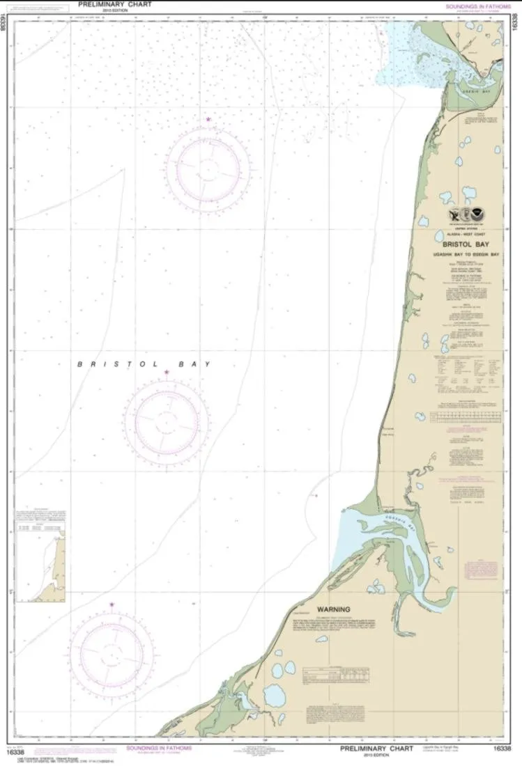
Introducing the NOAA Chart 16338, a must-have for mariners navigating the waters between Bristol Bay and Egegik Bay. This nautical chart is expertly printed by East View Geospatial, a certified NOAA and NGA print-on-demand printer, ensuring that you have access to the most reliable and up-to-date information available. The chart’s scale is 1:100,000, providing a detailed view of these important waterways.
The chart measures 118 inches by 81 inches, making it a substantial resource for any vessel. It is printed on PaperTyger, a lightweight and tear-resistant material that also offers water resistance. While this paper is not fully waterproof, it surpasses standard paper in durability, ensuring that it can withstand the rigors of marine conditions.
One critical aspect to note is that NOAA-OCS cancelled Raster and PDF chart 16338 on November 30, 2022. Therefore, this product does not meet U.S. and international carriage requirements for commercial vessels, as outlined in SOLAS Chapter V Regulation 19.2.1. However, it remains an excellent choice for recreational use, providing mariners with essential navigation information.
East View Geospatial ensures that all charts are printed with the latest Notice to Mariners (NTMs), thereby maintaining compliance with United States Coast Guard and international standards for both commercial and recreational vessels. This commitment to quality means you can trust this chart for accurate navigation.
| Chart Title: | NOAA Chart 16338 – Bristol Bay to Egegik Bay |
| Material: | Water-resistant PaperTyger |
| Scale: | 1:100,000 |
| Size: | 118 x 81 inches |
| Produced by: | East View Geospatial |
| Notice: | Chart 16338 cancelled as of November 30, 2022 |
When you choose the NOAA Chart 16338, you are investing in a product that is crafted with precision and care. The pre-production finishing guarantees superior quality, making this chart an indispensable tool for any sailor. It is designed to meet the needs of modern mariners, providing clear and accessible navigation data that is essential for safe travel on the water.
In conclusion, whether you are a seasoned mariner or a recreational boater, the NOAA Chart 16338 is an essential addition to your navigational resources. With its durable construction, accurate scale, and up-to-date information, this chart is designed to help you navigate the beautiful yet challenging waters of Bristol Bay to Egegik Bay with confidence.
Reviews
There are no reviews yet.