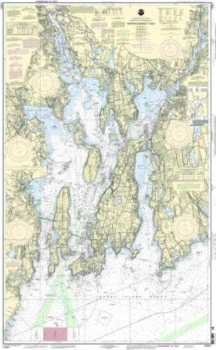
Introducing the 13221 Naragansett Bay Nautical Chart, an essential tool for any mariner navigating the intricate waters of the Eastern U.S. and Canada region. This NOAA-approved chart provides the most accurate and up-to-date information available, ensuring that your navigation is reliable and safe. Printed only after an order is received, each chart includes all necessary Notice to Mariners corrections, keeping you informed of any changes that may affect your journey.
With a scale of 1:40000, this chart offers a detailed representation of the waterways, allowing for precise navigation. The dimensions of the chart measure 53.63 inches in height and 33.33 inches in width, making it a substantial resource for both recreational and commercial mariners. The chart meets all U.S. and international carriage requirements for commercial vessels, making it a trusted choice for professionals in the maritime industry.
| Chart Details | Specifications |
| Brand | NOAA |
| Size | 53.63” H x 33.33” W |
| Scale | 1:40000 |
| Region | Eastern U.S. / Canada |
| Approval | U.S. Coast Guard Approved |
This chart is not only a regulatory requirement for commercial vessels but also an indispensable companion for leisure boaters who wish to explore the beautiful waterways of Naragansett Bay. The combination of expert craftsmanship and the most current data ensures that you can navigate with confidence.
In summary, choosing the 13221 Naragansett Bay NOAA Nautical Chart means investing in your safety and efficiency on the water. Stay informed, stay safe, and enjoy your maritime adventures with the best navigation tools at your disposal.


Reviews
There are no reviews yet.