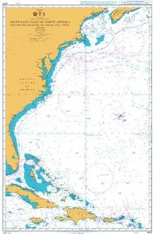
Introducing the BA Chart 4403, a meticulously produced nautical chart detailing the South East Coast of North America, including the beautiful Bahama Islands and the Greater Antilles. This chart, created by the United Kingdom Hydrographic Office (UKHO), is one of the world’s leading producers of nautical charts and is designed to meet the highest standards for safety and navigation.
This chart is not just a map; it is a crucial tool for mariners, providing comprehensive information that is essential for safe navigation. It has been corrected to the latest notice to mariners (NTM) at the point of sale, ensuring that you have the most up-to-date information at your fingertips. As mariners know, it is vital to stay informed about the latest navigational changes, and this chart provides that assurance.
One of the standout features of the BA Chart 4403 is its compliance with the Safety of Life at Sea (SOLAS) regulations. This means that it meets both U.S. and international carriage requirements, making it suitable for commercial vessels defined in SOLAS Chapter V Regulation 19.2.1.2353. This level of compliance is particularly important for those who operate in busy maritime areas, where navigational accuracy is critical.
Whether you are a professional mariner, a commercial operator, or a recreational sailor, this chart is ideal for a variety of uses. The charts within this series consist of a range of scales, which are useful for passage planning, ocean crossings, and coastal navigation. For mariners, using the largest scale nautical chart appropriate to their needs is advisable, especially in busy seaways.
| Features | Details |
| Corrected NTM | Up-to-date at point of sale |
| SOLAS Compliance | Meets U.S. & international requirements |
| U.S. Coast Guard Approval | Approved for commercial vessel use |
| Produced by | United Kingdom Hydrographic Office |
In particularly busy seaways, such as the English Channel, Gulf of Suez, and the Malacca and Singapore Straits, standard nautical charts are supplemented by mariners’ routeing guides. These guides provide invaluable advice on route planning in these complex areas, ensuring that you can navigate safely and efficiently.
It’s important to note that while the BA Chart 4403 provides essential navigational information, it is ultimately the responsibility of the mariner to maintain and correct the chart to remain compliant with SOLAS regulations. Safe navigation is paramount, and having the most accurate and reliable charts is a key part of that process.
In conclusion, the BA Chart 4403 is an indispensable resource for anyone navigating the South East Coast of North America and its surrounding waters. Its combination of accuracy, compliance, and thorough detail makes it a must-have for mariners who value safety and precision in their navigation efforts.


Reviews
There are no reviews yet.