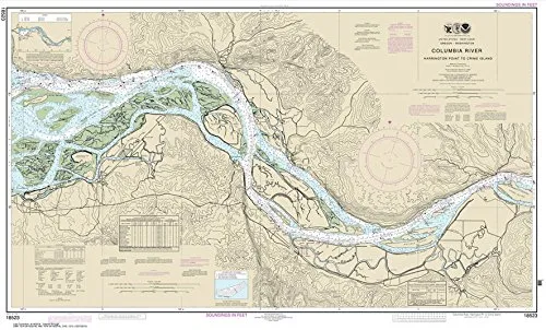


Experience the beauty and navigational precision of the Columbia River with the NOAA Chart 18523, which covers the area from Harrington Point to Crims Island. This chart, measuring 26.5 x 43.8 inches, is expertly printed by Paradise Cay Publications, Inc. on high-quality, water-resistant paper. It is designed specifically for those who value both accuracy and durability when navigating the waters.
The NOAA Chart 18523 is not just any chart; it is certified by NOAA and the U.S. Coast Guard, making it an essential tool for commercial vessels. This certification process ensures that every chart meets stringent standards for scale, print quality, and usability. Only those charts printed by NOAA-certified agents can carry the NOAA logo, and Paradise Cay Publications has earned this prestigious recognition.
Each chart is printed on demand, utilizing the most recent data provided by NOAA to ensure you have the most up-to-date information available. This commitment to quality means that you can trust this chart for your navigational needs. Additionally, the chart arrives rolled, not folded, preserving its integrity and making it easy to display or store.
| Feature | Details |
| Size | 26.5 x 43.8 inches |
| Material | High-quality water-resistant paper |
| Certification | NOAA and U.S. Coast Guard certified |
| Print Quality | Display quality, printed on demand |
| Seller | Exclusive to Ruby & Rudy’s Books |
It’s important to note that Ruby & Rudy’s Books are the exclusive sellers of this particular brand of nautical charts. This exclusivity ensures that you receive an authentic product that meets all quality standards. Other sellers using this listing may not be authorized to sell this brand, and they may offer inferior products that do not meet NOAA’s rigorous approval process.
When you invest in NOAA Chart 18523, you’re not just purchasing a chart; you’re acquiring a reliable navigational tool that has undergone a thorough vetting process. NOAA provides digital images to certified agents who must submit samples for evaluation. This ensures that only the best products reach the market, and Paradise Cay Publications is proud to be part of this elite group.
In conclusion, the NOAA Chart 18523 is an invaluable asset for any mariner navigating the Columbia River. With its certified quality, durability, and accuracy, it is the perfect choice for both leisure and commercial navigation. Explore our complete line of chart products, including PAPER CHARTS, WATERPROOF CHARTS, SMALL FORMAT CHARTS, BOOKLET CHARTS, and BOOK CHARTS, to find the perfect chart for your needs.


Reviews
There are no reviews yet.