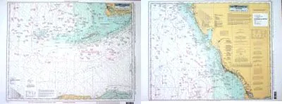
Discover the ultimate navigation tool with the Havanah to Tampa, FL Laminated Nautical Navigation & Fishing Chart by Captain Segull’s Nautical Sportfishing Charts. This meticulously designed chart, known as Chart # HTK42, is perfect for both seasoned anglers and novice fishermen alike. Its double-sided format and laminated finish ensure durability while providing essential information for successful fishing outings.
Measuring an impressive 19.5 inches by 26.5 inches, this fishing chart covers offshore areas extending 90 to 100 miles out. On Side A, you will find detailed navigation information from the southern shores of Havana, Cuba, through the Straits of Florida, and east to Florida Bay. It also extends north to Whitewater Bay, offering a comprehensive view of this bustling fishing region.
Flip to Side B, and you will discover invaluable details from Northwest Cape north to Tampa Bay, FL. This chart is designed for easy readability, making it simple to locate key fishing areas, wrecks, reefs, and local names. The GPS coordinates are marked with precision, extending out to the thousandths of a minute, ensuring that you can navigate the waters with confidence.
This laminated fishing chart not only enhances your fishing experience but also provides crucial insights into local amenities that can benefit anglers on the water. The vibrant colors and clear graphics ensure that every detail is visible, allowing you to plan your fishing trips effectively.
Whether you are going for a casual day of fishing or planning a serious offshore expedition, the Havanah to Tampa fishing chart is an essential companion. It combines practicality with expert design, making it an indispensable resource for anyone looking to explore the fishing opportunities along Florida’s stunning coastline.
| Feature | Details |
| Chart Name | Havanah to Tampa, FL Laminated Nautical Fishing Chart |
| Brand | Captain Segull’s Nautical Sportfishing Charts |
| Size | 19.5′ x 26.5′ |
| Coverage | 90 to 100 miles offshore |
| Side A Coverage | South from Havana, Cuba to Florida Bay, North to Whitewater Bay |
| Side B Coverage | NW Cape to Tampa Bay, FL |
This chart is more than just a piece of paper; it is your gateway to adventure on the water. With the Havanah to Tampa fishing chart in hand, you’ll be able to navigate with ease and find the best fishing spots available. Enjoy your time on the water and make the most of your fishing trips with this essential guide!


Reviews
There are no reviews yet.