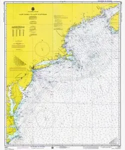
Discover the captivating world of maritime history with the Historical Nautical Chart 13003LORANA-10-1975. This stunning chart, produced by OceanGrafix, covers the area from Cape Sable to Cape Hatteras, reflecting the geographical features and navigational routes of the year 1975. While this chart is not intended for navigational purposes, it serves as a beautiful piece of art and a valuable collectible for enthusiasts of nautical history.
The Historical Nautical Chart 13003LORANA-10-1975 is a fascinating glimpse into the past. This chart provides a visual representation of the nautical landscape as it was known in the mid-1970s. As you delve into its details, you will uncover the intricacies of the coastlines, water depths, and significant landmarks that were vital to sailors and navigators of that era.
| Chart Title | Historical Nautical Chart 13003LORANA-10-1975 |
| Coverage Area | MA, Cape Sable to Cape Hatteras |
| Year | 1975 |
| Brand | OceanGrafix |
This chart not only serves as a decorative element for your home or office but also as a conversation starter among fellow maritime enthusiasts. Its historical significance adds depth to its beauty, making it an ideal gift for collectors or anyone with a passion for nautical themes.
When displayed, the Historical Nautical Chart 13003LORANA-10-1975 brings a sense of adventure and exploration into any space. It’s a reminder of the rich history of navigation and the ever-changing nature of our coastlines. Whether you are an avid sailor, a history buff, or simply someone who appreciates fine art, this chart is sure to impress.
In conclusion, the Historical Nautical Chart 13003LORANA-10-1975 is more than just a chart; it’s a piece of history. With detailed representations of the coastal areas from Cape Sable to Cape Hatteras, this chart allows you to appreciate the maritime heritage of the region in a unique and engaging way.


Reviews
There are no reviews yet.