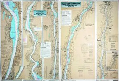
Discover the beauty and the rich fishing opportunities of the Hudson River with the Captain Segull’s Nautical Sportfishing Chart. This expertly designed laminated chart measures 19.5 inches by 26.5 inches, making it the perfect companion for any fishing enthusiast looking to navigate the waters from New York City to Troy, NY.
Our inshore fishing chart is specifically tailored for anglers who want to explore fishing areas just 1-2 miles off the coast. It provides detailed information about the bays and local fishing spots, ensuring you have access to the best locations along the Hudson River. The chart is not only informative but also highly practical, featuring local names and GPS coordinates that make it easy for you to find your way.
| Attribute | Details |
| Brand | Captain Segull’s Nautical Sportfishing Charts |
| Size | 19.5′ x 26.5′ |
| Material | Laminated |
| Chart Type | Inshore Fishing Chart |
| Coverage Area | Hudson River from New York City to Troy, NY |
| Features | Local names and GPS coordinates included |
The durability of the laminated finish ensures that this chart will withstand the elements, making it ideal for use on the water or during your fishing trips. Whether you’re an experienced angler or just starting out, this chart is an essential tool for navigating the Hudson River’s waterways.
With its clear and precise details, you’ll be able to locate various fishing hotspots and take full advantage of the rich marine life in the Hudson River. Don’t miss out on your chance to enhance your fishing experience with this valuable resource.
Get ready to embark on your next fishing adventure with Captain Segull’s Hudson River Nautical Chart. It serves as both a practical guide and a beautiful representation of this stunning waterway, making it a great addition to your fishing gear.


Reviews
There are no reviews yet.