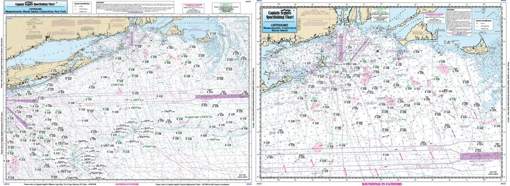
Introducing the essential Offshore Fishing Chart designed specifically for avid anglers and navigation enthusiasts. This high-quality laminated chart, produced by Captain Segull’s Nautical Charts, Inc., is perfect for those venturing into the waters off Massachusetts, Rhode Island, and Connecticut.
The chart measures a generous 19.5 inches by 26.5 inches, providing ample space to detail critical fishing locations and navigation routes. It features two sides:
| Side A | From Nantucket Shoals to mid Long Island, NY, covering all canyons including Veatch Canyon to Hudson Canyon. |
| Side B | Offers a blow-up view of crucial fishing spots off Block Island, showcasing local fishing areas such as the Dump, The Finger’s, and Cox’s Ledge. |
Each location is marked with local names and includes GPS coordinates, making it easier for you to navigate to the best fishing spots. Whether you’re a seasoned fisherman or a novice looking to explore, this chart is an indispensable tool for enhancing your offshore fishing experience.
The laminated material ensures durability and resistance to water damage, allowing you to use the chart in various weather conditions without fear of wear and tear. You can take it on your boat, to the beach, or even use it at home for planning your next fishing trip.
With its detailed illustrations and user-friendly layout, the Captain Segull’s Fishing Chart is not just a navigational tool; it’s your guide to discovering the rich marine life and fishing potential of the waters off MA, RI, and CT.
Planning a fishing trip without this chart would be like heading out without your rod and reel. Make sure you have this chart on board to ensure a successful outing.
Don’t miss out on the opportunity to explore the depths of the ocean and the bountiful fishing grounds it has to offer. Equip yourself with Captain Segull’s Nautical Fishing Chart and set sail towards your next adventure.


Reviews
There are no reviews yet.