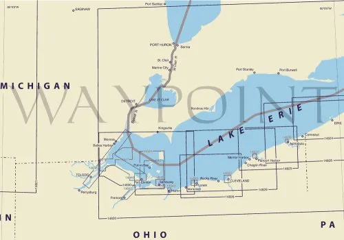
The Nautical Chart 14825, covering the region from Ashtabula to the Chagrin River, is an essential tool for mariners navigating in the Eastern U.S. and Canada. This chart is created by OceanGrafix, a trusted name in marine navigation, and is designed to meet both U.S. and international carriage requirements for commercial vessels. It features the latest updates, ensuring that you have the most accurate information at your fingertips.
One of the standout features of this chart is its scale of 1:80000, which offers a detailed view of the waterways, allowing for precise navigation. Furthermore, every chart is printed only after an order is received. This means that you always receive the most up-to-date information, reflecting all the latest Notice to Mariners corrections. Such diligence in updating ensures that you can navigate with confidence.
| Chart Title | Chart 14825 – Ashtabula to Chagrin River |
| Brand | Charts-On-Demand |
| Size | 28.56′ x 38.33′ |
| Scale | 1:80000 |
| Features | NOAA-approved, updated with latest corrections, meets commercial vessel requirements |
This chart is not just a piece of paper; it is a vital resource for safe navigation. By utilizing the Nautical Chart 14825, you ensure that you are equipped with the most reliable tools for your maritime journey. Whether you’re a seasoned mariner or a novice taking to the waters, having a NOAA-approved chart can significantly enhance your navigation experience.
In conclusion, the Nautical Chart 14825 from Ashtabula to Chagrin River is a must-have for anyone navigating these waters. Its detailed scale, accurate updates, and compliance with maritime regulations make it an indispensable resource. Equip yourself with this chart and navigate with confidence.


Reviews
There are no reviews yet.