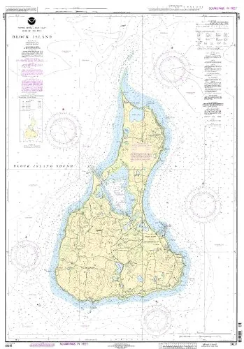
Introducing the 13217 Block Island nautical chart, a must-have for any mariner navigating the Eastern U.S. and Canada region. Designed with precision, this chart is printed only after an order is received, ensuring that you receive the most up-to-date information available. OceanGrafix, the leading provider of NOAA-approved nautical charts, guarantees that all Notice to Mariners corrections are applied, providing you with accurate and reliable navigation aids.
The 13217 Block Island chart meets both U.S. and international carriage requirements for commercial vessels, and it is U.S. Coast Guard approved. This feature enhances its credibility, making it an essential tool for professional mariners and boating enthusiasts alike.
With a scale of 1:15000, this chart provides detailed representation of the area, ensuring that every navigational element you need is clearly marked. The dimensions of the chart are 41.04 inches in height and 28.93 inches in width, making it a comprehensive resource for on-board navigation.
| Feature | Description |
| Brand | NOAA |
| Scale | 1:15000 |
| Dimensions | 41.04′ H x 28.93′ W |
| Corrections | All Notice to Mariners corrections applied |
| Approval | U.S. Coast Guard approved |
| Carriage Requirements | Meets U.S. and international requirements |
Whether you are a commercial vessel operator or a recreational sailor, the 13217 Block Island nautical chart is designed to provide you with essential navigational data. The commitment to quality and accuracy that OceanGrafix embodies means that you can trust this chart to guide you safely across the waters.
Investing in the 13217 Block Island nautical chart means you are ensuring that you have the most reliable navigation tool at your disposal. Don’t compromise on safety and accuracy; choose OceanGrafix’s NOAA-approved charts for your maritime adventures!


Reviews
There are no reviews yet.