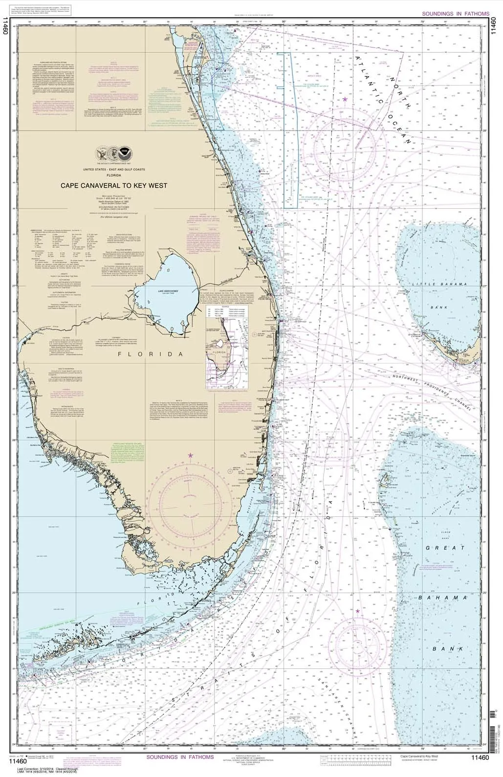


Introducing the NOAA Chart 11460, a meticulously crafted nautical chart that spans from Cape Canaveral to Key West. This chart is produced by Paradise Cay Publications, Inc., a name synonymous with quality and reliability in marine navigation. With a robust design that features high-quality, water-resistant paper, this chart is perfect for mariners who demand precision and durability from their navigation tools.
What sets the NOAA Chart 11460 apart is its commitment to accuracy. Each chart is printed on demand, utilizing the most recent data provided by NOAA (National Oceanic and Atmospheric Administration). This means that you are not only receiving a chart that is visually stunning but one that is also backed by the latest navigational information, ensuring safe and efficient travel across the waters.
The chart arrives rolled, not folded, maintaining its integrity and ensuring it is ready for immediate use. This attention to detail reflects the commitment Paradise Cay Publications has to providing display-quality products that mariners can rely on.
Furthermore, this chart has been certified by NOAA and the U.S. Coast Guard, which means it meets the strict standards necessary for carriage on commercial vessels. When you choose this chart, you are choosing a product that has undergone rigorous evaluation, ensuring that it meets all necessary scale and print quality requirements.
Ruby & Rudy’s Books proudly serves as the exclusive seller of this brand of nautical charts. It’s important to note that other sellers using this listing may not be authorized to sell this product. They could be offering inferior quality charts, which can be a serious risk for navigation. Only charts printed by certified NOAA Chart Agents are authorized to carry the NOAA logo, and Paradise Cay Publications charts are among those trusted options.
As a NOAA-certified agent, Paradise Cay Publications has passed a stringent vetting process. This includes submitting samples to NOAA for evaluation, where the charts are tested for scale, print quality, and durability. The materials used are designed to withstand wear, allowing for plotting without compromising the integrity of the chart. The water-resistant paper used meets NOAA’s high standards, ensuring that your nautical chart can withstand the elements, making it a reliable companion on your journeys.
| Product Features | Description |
| Water-Resistant Paper | Durable and capable of withstanding marine conditions. |
| NOAA Certification | Certified by NOAA and the U.S. Coast Guard for reliable navigation. |
| Exclusive Seller | Available exclusively through Ruby & Rudy’s Books. |
| Print on Demand | Utilizes the most recent NOAA data for accuracy. |
| Preparation | Arrives rolled and ready for immediate use. |
We encourage you to explore our complete line of chart products, including PAPER CHARTS, WATERPROOF CHARTS, SMALL FORMAT CHARTS, BOOKLET CHARTS, and BOOK CHARTS. Each product is designed with the needs of mariners in mind, ensuring that you have access to the best navigation tools available.
In conclusion, the NOAA Chart 11460 is more than just a navigation tool; it is a commitment to safety, quality, and accuracy on the water. Whether you are a seasoned sailor or a beginner, this chart is an indispensable resource for your maritime adventures.

Reviews
There are no reviews yet.