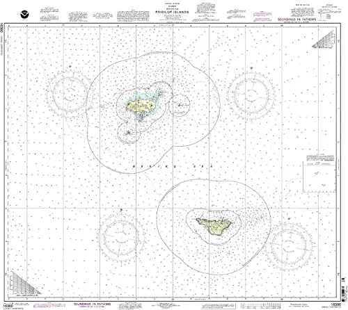
The NOAA Pribilof Islands Nautical Chart is an essential tool for mariners, offering the most current and accurate navigation information. Partnering with OceanGrafix, the National Oceanic and Atmospheric Administration ensures that this chart is printed on demand, allowing for immediate access to the latest updates. This chart includes all relevant Notice to Mariners (NTM) corrections applied at the time of printing, ensuring its reliability for both commercial and recreational use.
| Brand | NOAA |
| Features | On-demand printing, NTM corrections, U.S. Coast Guard approved, Meets SOLAS regulations |
With the increasing need for precise navigation, the NOAA Pribilof Islands Nautical Chart meets the stringent requirements set forth by the International Convention for the Safety of Life at Sea (SOLAS). Specifically, it adheres to the definitions outlined in SOLAS Chapter V Regulation 2.2 and satisfies the carriage requirements specified in Regulation 19.2.1.4.
This nautical chart is more than just a map; it is a vital resource that enhances maritime safety. Mariners can trust that they are equipped with the most up-to-date information, which is crucial for safe navigation through challenging waters.
The chart’s design includes various navigational aids and details that are essential for successful marine travel. As it is printed on demand, mariners can obtain a fresh copy any time they need, reflecting the latest updates and corrections.
Whether you are a seasoned professional or a recreational boater, having the NOAA Pribilof Islands Nautical Chart on board is indispensable. It not only provides essential data but also ensures compliance with maritime regulations, making it a wise investment for any seafarer.
In summary, the NOAA Pribilof Islands Nautical Chart stands out due to its accuracy, reliability, and adherence to the highest maritime standards. Equip yourself with this critical resource and navigate with confidence.


Reviews
There are no reviews yet.