
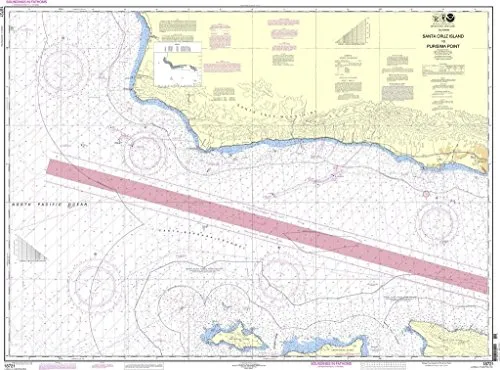
Introducing the NOAA Santa Cruz Island to Purisima Point Nautical Chart, an essential tool for both commercial and recreational mariners. This chart is printed on demand, ensuring that you receive the most accurate and up-to-date information available at the time of printing. In collaboration with OceanGrafix, the National Oceanic and Atmospheric Administration (NOAA) has developed this chart to provide mariners with reliable navigation aids.
One of the standout features of this nautical chart is that it incorporates all Notice to Mariners (NTM) corrections at the time of printing. This means that you can trust that the information is current and reflects the latest updates, which is crucial for safe navigation. The chart adheres to the standards set forth in SOLAS Chapter V Regulation 19.2.1.385, making it compliant with both U.S. and international carriage requirements for commercial vessels.
Moreover, the NOAA Santa Cruz Island to Purisima Point Nautical Chart is U.S. Coast Guard approved, further affirming its reliability. Mariners can navigate with confidence knowing they have a chart that meets rigorous safety standards. The design of the chart is not only functional but also user-friendly, making it easy to read and interpret while out on the water.
Below is a summary of the key features of the NOAA Santa Cruz Island to Purisima Point Nautical Chart:
| Feature | Description |
| Printing Method | Printed on demand, ensuring up-to-date information |
| Corrections | All Notice to Mariners corrections applied |
| Compliance | Meets U.S. and international SOLAS carriage requirements |
| Approval | U.S. Coast Guard approved for safe navigation |
In conclusion, the NOAA Santa Cruz Island to Purisima Point Nautical Chart is an indispensable resource for anyone navigating these waters. With its up-to-date information, compliance with safety regulations, and user-friendly design, it’s clear that this chart is made with the mariner’s needs in mind. Whether you are a seasoned captain or a recreational boater, this nautical chart will serve you well in your maritime adventures.


Reviews
There are no reviews yet.