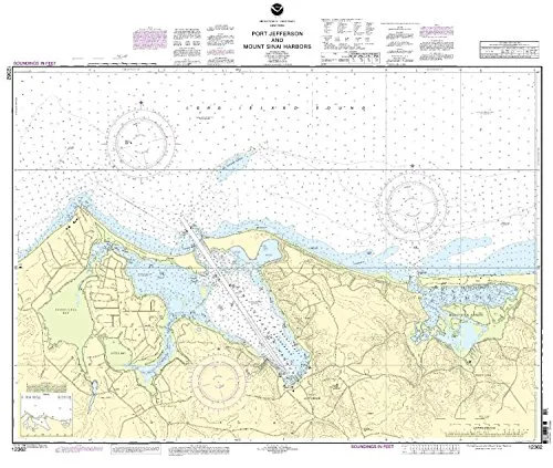

Navigating the waters around Port Jefferson and Mount Sinai Harbors has never been easier thanks to the expertly crafted nautical chart provided by OceanGrafix. This chart is not just any map; it represents the most up-to-date, NOAA-approved nautical charts available to mariners today. With a scale of 1:10000, this chart covers the Eastern U.S. and Canada region, ensuring that you have the detailed information you need for safe and effective navigation.
One of the standout features of this chart is that it is printed only after an order has been received. This means that you can be confident in receiving the latest information, as all Notice to Mariners corrections are promptly applied. Whether you are a seasoned mariner or a novice boater, having the most current data at your fingertips is crucial for making informed decisions on the water.
| Chart Features | Details |
| Brand | NOAA |
| Size | 34.23” H x 41.14” W |
| Scale | 1:10000 |
| Coverage Area | Eastern U.S./Canada Region |
| Approval | U.S. Coast Guard approved |
| Commercial Compliance | Meets U.S. and international carriage requirements for commercial vessels |
Safety is paramount when navigating waterways, and this chart helps ensure compliance with all necessary regulations. It meets both U.S. and international carriage requirements for commercial vessels, making it an essential tool for any maritime professional. The U.S. Coast Guard has recognized the reliability of this chart, giving you peace of mind that you are equipped with a trustworthy navigation resource.
In addition to its functional benefits, the chart’s dimensions (34.23 inches in height and 41.14 inches in width) make it a perfect fit for onboard use. It can easily be displayed in your cabin or control area, always within arm’s reach when you’re out on the water. The visual clarity of the chart allows for quick reference, highlighting important navigational aids, hazards, and essential features of the harbors.
In conclusion, the Port Jefferson & Mount Sinai Harbors nautical chart by OceanGrafix is an indispensable tool for anyone navigating these waters. With its NOAA approval, up-to-date information, and compliance with maritime regulations, you can trust that you are making safe choices on your journey. Don’t leave your navigation to chance; equip yourself with the best nautical chart available and sail with confidence.


Reviews
There are no reviews yet.