
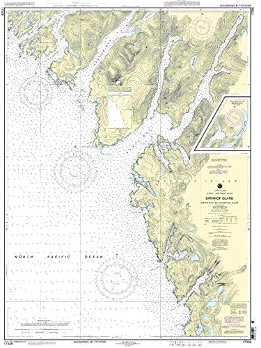
Introducing the Snipe Bay to Crawfish Inlet Nautical Chart, a vital tool for mariners navigating the Pacific Northwest and Alaska region. This chart is meticulously crafted by OceanGrafix, which is renowned for providing the most up-to-date, NOAA-approved nautical charts available on the market today. With a scale of 1:40000, this detailed chart measures 44.72 inches in height and 33.08 inches in width, making it an essential addition to your maritime navigation resources.
One of the standout features of this nautical chart is that it is printed only after an order has been received. This unique aspect ensures that you receive the most current and accurate information available, which is vital for safe navigation. Furthermore, all Notice to Mariners corrections are applied, guaranteeing that your chart reflects the latest updates and changes in the waterways.
| Feature | Description |
| Brand | NOAA (National Oceanic and Atmospheric Administration) |
| Chart Size | 44.72′ H x 33.08′ W |
| Scale | 1:40000 |
| Compliance | Meets U.S. and international carriage requirements for commercial vessels |
| Approval | U.S. Coast Guard approved |
This nautical chart is not just a piece of paper; it is an essential navigational aid that meets all the necessary standards for commercial vessels. Whether you are a professional mariner or a recreational boater, having access to precise and reliable nautical information is crucial for safe navigation.
In conclusion, the Snipe Bay to Crawfish Inlet Nautical Chart is a comprehensive resource for anyone navigating these waters. It is designed to provide clarity and accuracy, ensuring that you can safely chart your course. Don’t compromise on your navigational tools. Order your NOAA-approved nautical chart today and navigate with confidence!


Reviews
There are no reviews yet.