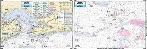
Welcome to the ultimate guide for navigating the pristine waters of St. Louis Bay, MS. Our Laminated Nautical Navigation & Fishing Chart by Captain Segull’s Nautical Charts is designed specifically for fishing enthusiasts and outdoor adventurers. This chart, identified as Chart # SLM308, is your key to unlocking the hidden treasures of inshore fishing in this beautiful region.
Measuring 12 inches by 18 inches, this chart is compact yet comprehensive. Its laminated surface ensures durability and water resistance, making it ideal for use on small boats and kayaks. Whether you’re a seasoned angler or just starting your fishing journey, this chart will enhance your experience on the water.
| Product Features | Description |
| Laminated Design | Durable and water-resistant, perfect for outdoor use. |
| Double-Sided | Offers extensive coverage of fishing areas, wrecks, and reefs. |
| GPS Details | Accurate GPS coordinates down to the thousandths of a minute. |
| Local Names | Features local names and amenities for better navigation. |
This fishing chart provides a detailed overview of St. Louis Bay to the Cat Island Channel, MS. It highlights important fishing areas, wrecks, and reefs, making it easier for you to locate the best spots for your fishing adventures. The inclusion of local names and amenities enhances your navigation experience, ensuring you can make the most of your time on the water.
Imagine setting out on your kayak, chart in hand, with a clear understanding of where to find the best catches. The laminated surface protects the chart from moisture and wear, allowing you to focus on your fishing without worrying about damaging your essential navigation tool.
Whether you’re planning a day trip or a weekend fishing expedition, this chart is an indispensable companion. It empowers you to explore the waters of St. Louis Bay with confidence, armed with detailed information that can significantly improve your fishing results.
In summary, Captain Segull’s Nautical Fishing Chart for St. Louis Bay is more than just a map; it’s a gateway to adventure. With its user-friendly design, comprehensive details, and durable construction, it is perfect for all fishing enthusiasts. Grab your chart today and start your journey toward a successful fishing experience in one of Mississippi’s most beautiful locales.


Reviews
There are no reviews yet.