
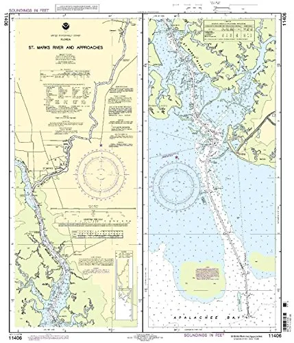
Discover the St. Marks River and its approaches through this expertly crafted NOAA nautical chart. With a scale of 1:80000, this detailed chart covers the Eastern U.S. and Canada region, providing mariners with crucial information for safe navigation.
One of the standout features of this chart is its commitment to accuracy. OceanGrafix ensures that each chart is printed only after an order is received, which means you will always receive the most current information available. This practice guarantees that all Notice to Mariners corrections are applied, making it a reliable resource for your maritime journeys.
Moreover, this nautical chart meets both U.S. and international carriage requirements, which is essential for commercial vessels. The U.S. Coast Guard has approved this chart, further highlighting its reliability and adherence to safety standards.
Here are some dimensions and features of the chart:
| Feature | Details |
| Scale | 1:80000 |
| Size | 31.32′ H x 14.92′ W |
| Region | Eastern U.S./Canada |
| Approval | U.S. Coast Guard Approved |
In conclusion, for any mariner looking to navigate the waters of the St. Marks River, this NOAA nautical chart is an essential tool. With its up-to-date information, compliance with safety regulations, and user-friendly format, it stands out as a preferred choice for both recreational and commercial use.


Reviews
There are no reviews yet.