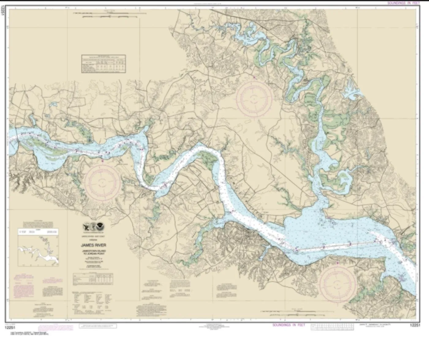
Explore the detailed NOAA Chart 12251, covering the James River from Jamestown Island to Jordan Point. This chart is not just a piece of paper; it’s a vital tool for navigation, crafted with precision by East View Geospatial, a certified NOAA and NGA print-on-demand printer. The chart is printed on PaperTyger, an innovative material that is lightweight, tear-resistant, and water-resistant, making it an ideal companion for both recreational and professional mariners.
It’s crucial to note that NOAA-OCS has cancelled Raster and PDF chart 12251, Edition #24, effective November 16, 2022. Consequently, this product does not meet U.S. and international carriage requirements for commercial vessels as defined in SOLAS Chapter V Regulation 19.2.1. However, for personal use and non-commercial navigation, this chart remains a reliable resource.
The map scale is set at 1:40,000, providing an extensive overview of the area while allowing for detailed navigation. With dimensions of 86 x 109 inches, this chart offers ample space to showcase intricate details and features of the river and surrounding landscapes.
| Product Features | Details |
| Brand | East View Geospatial |
| Material | PaperTyger – lightweight, tear-resistant, water-resistant |
| Map Scale | 1:40,000 |
| Map Size | 86 x 109 inches |
| Edition Status | Cancelled – Edition #24 as of Nov 16, 2022 |
Each chart is meticulously printed using high-resolution images, ensuring clarity and precision. Whether you are navigating the beautiful waters of the James River or simply using it as a decorative piece, this chart offers both functionality and aesthetic appeal.
East View Geospatial prides itself on delivering superior quality products. The pre-production finishing enhances the durability and usability of the chart, ensuring that it withstands the elements. The smooth matte finish contributes to its easy readability, making it an excellent choice for seasoned navigators and newcomers alike.
In conclusion, the NOAA Chart 12251 is an essential asset for anyone interested in the waterways of Virginia. Its water-resistant features and high-quality printing make it a reliable choice for both casual and serious mariners. Although it does not meet commercial carriage requirements, its value for personal navigation cannot be overstated.

Reviews
There are no reviews yet.